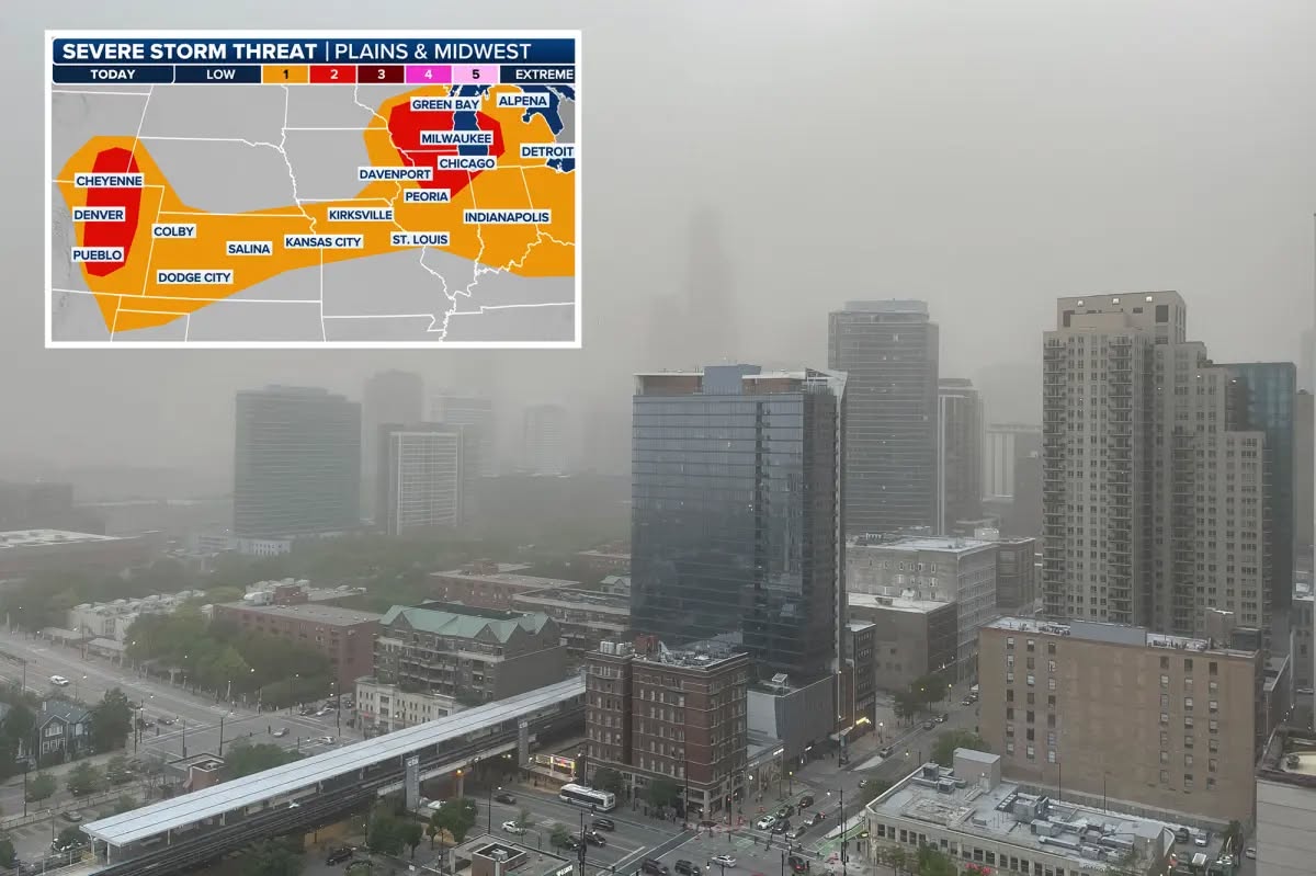
Chicagoland is facing a significant severe weather event, with the National Weather Service issuing multiple alerts for the region. A powerful clash of air masses brought the threat of severe thunderstorms, capable of producing large hail, damaging winds, and even tornadoes, putting millions of residents on high alert.
The storms were part of a broader weather pattern affecting the Midwest, with Chicago and surrounding areas experiencing heightened risks of flash flooding and destructive weather conditions.
According to FOX 32 Chicago, “The stronger cells could produce hail, damaging wind, and even tornadoes, but the biggest threat will be gusty winds as the storms generally move from west to east.”
The report highlighted that the severe weather threat was expected to subside between sunset and overnight as the frontal boundary moved through the region.
However, the immediate concern was the potential for storms to drop 1-2 inches of rain in a short period, increasing the risk of flash flooding. “Communities around Davenport, Iowa, and Chicago have already experienced significant flooding, with areas recently placed under Flash Flood Warnings and Flash Flood Emergencies,” the report noted.
The high humidity and dew points contributed to the volatile weather conditions, making thunderstorms particularly intense.
FOX 32 meteorologist Mike Caplan emphasized the severity, stating, “In addition to the severe weather threat, dew points and precipitable water values are expected to be high, meaning any thunderstorm that develops will have the potential to drop 1-2 inches of rain in a short period, leading to a flash flooding threat.”
This combination of factors underscored the need for residents to remain vigilant and prepared for rapidly changing conditions.
The storms also provided some relief from poor air quality caused by lingering wildfire smoke from Canada. “In addition to providing some drought relief, the wet weather is expected to help clear the air of wildfire smoke that has lingered over the region,” FOX 32 reported.
This came after an “Air Pollution Action Day” was declared in Chicago on Tuesday, with authorities urging sensitive groups to limit outdoor activities due to unhealthy ozone levels.
As the storms moved through, the National Weather Service advised residents to take precautions, particularly when driving in severe conditions. “Just 6 inches of moving water can knock an adult off their feet, while a foot of floodwater can cause a vehicle to stall and float away,” the report cautioned, highlighting the dangers of flash flooding. Drivers were urged to avoid flooded roads and underpasses to ensure safety.
Looking ahead, the forecast indicated a shift to more pleasant weather following the storms. “Once the front moves through, it should bring more pleasant weather, with highs expected to reach only the 70s on Friday and 80s on Saturday before more wet weather moves in over the weekend and into next week,” according to FOX 32. This offered some reassurance to residents bracing for the immediate impacts of the severe weather event.
The severe weather threat on July 16, 2025, served as a reminder of the importance of staying informed and prepared. With the potential for damaging winds, large hail, and flash flooding, Chicagoans were urged to monitor updates from local meteorologists and heed safety warnings to protect themselves and their property.
Source: FOX 32 Chicago, “Chicago among 21 million under threat of severe storms packing large hail, damaging wind,” published July 16, 2025.